Missouri Rivers Flood as Storm System Batters Region
Flood warnings stretch across Missouri and Illinois as the Mississippi, Missouri, and Meramec rivers surge above flood stage following days of heavy rainfall — with some warnings lasting through June 21.
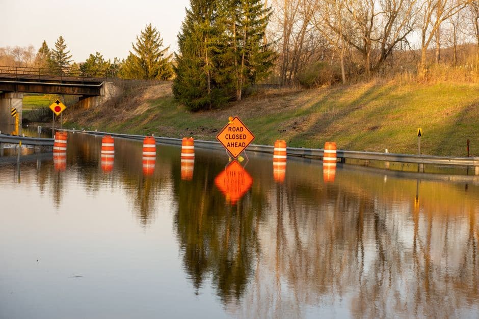
JEFFERSON CITY, MISSOURI — A multi-day storm system has pushed several Missouri rivers above flood stage, prompting the National Weather Service to issue and extend flood warnings across a wide swath of Missouri and Illinois through the weekend of June 21, 2026. Heavy rainfall across the northern portions of river basins has driven elevated water levels on the Mississippi, Missouri, Meramec, and Illinois rivers at multiple gauge locations.
Mississippi River Flooding at Chester and Cape Girardeau
The Mississippi River at Chester crested near 28.8 feet on the morning of June 18, according to the National Weather Service in St. Louis, well above the flood stage of 27.0 feet. At 11:30 a.m. CDT Thursday, the river stood at 28.6 feet and was nearing its crest. The NWS St. Louis office reported that the river rose above flood stage on June 15, and forecasters expect it to fall below flood stage early Saturday morning, with the flood warning in effect until June 21 at 9:24 a.m. CDT. At 28.0 feet, unleveed islands near Chester and a prison farm flood.
Farther south, the Mississippi River at Cape Girardeau was recorded at 31.8 feet as of 11:00 a.m. CDT Thursday, just below the flood stage of 32.0 feet. The NWS Paducah office forecast the river to rise to a crest of 32.0 feet Friday morning before falling below flood stage Friday afternoon, with the warning in place until June 19 at 1:00 p.m. CDT. At flood stage, the Mississippi River backs into several creeks, producing additional flooding in the area. Recent heavy rainfall across northern portions of the river basin was cited as the cause of the ongoing rise.
Missouri and Meramec Rivers Also Running High
The Missouri River at Hermann stood at 21.2 feet as of 7:30 p.m. CDT Wednesday, above flood stage of 21.0 feet. NWS St. Louis issued a flood warning for that location through Friday morning, noting the river was expected to fall below flood stage overnight. At Hermann, flood stage impacts include inundation of the southern end of School House Road south of Rhineland at 21.3 feet.
The Missouri River at St. Charles was at 25.1 feet as of noon CDT Wednesday, right at flood stage of 25.0 feet. NWS St. Louis forecast the river to fall below flood stage that same evening. Near Chamois, the Missouri River was recorded at 17.4 feet as of 7:00 a.m. CDT Wednesday against a flood stage of 17.0 feet, with a warning in effect until June 18 at 11:40 p.m. CDT. At that location, lower-lying bottomland begins to flood at the flood stage threshold.
The Meramec River near Arnold was at 24.1 feet as of 8:30 p.m. CDT Wednesday, just above its flood stage of 24.0 feet. NWS St. Louis forecast the river to crest at 24.3 feet Thursday morning before falling below flood stage early Friday. The warning runs through Saturday morning, June 20, at 7:00 a.m. CDT. Corisande Hills Road and Meramec Bottom Road between Hagemann Road and Highway 21 begin flooding at 24.0 feet.
Severe Weather Also Struck the Region Wednesday
Alongside the flooding, a round of severe thunderstorms struck portions of Missouri and Illinois on June 17. The NWS Kansas City/Pleasant Hill office issued multiple tornado warnings during the late afternoon hours for areas including Clinton, Urich, Hartwell, Deepwater, Creighton, and La Due in Henry and Johnson counties. Radar-indicated rotation was detected near Urich, approximately 8 to 12 miles southeast of Garden City, moving east at 30 mph, with hazards including tornado-capable rotation and quarter-size hail.
NWS St. Louis also issued tornado warnings for northeastern Audrain County, southwestern Pike County, and southwestern Ralls County, with a storm detected 5 miles northwest of Laddonia moving east at 40 mph. Locations including Laddonia, Farber, and Vandalia were in the warning area. Earlier in the afternoon, severe thunderstorm warnings were issued for Madison, Holliday, and Paris in Monroe and Audrain counties, with ping pong ball-size hail and 60 mph wind gusts reported by radar. A tornado watch remained in effect until 10:00 p.m. CDT for 20 Missouri counties and 16 Illinois counties.
Wind advisories were also issued for portions of central, east central, and northeast Missouri on June 17, with southwest winds of 20 to 30 mph and gusts up to 50 mph expected to blow down tree limbs and cause scattered power outages. All tornado and severe thunderstorm warnings from June 17 have since expired, according to NWS records.
Residents in flood-affected areas are urged to monitor National Weather Service updates and avoid flooded roadways. Additional river forecast information is available at weather.gov/safety/flood.


