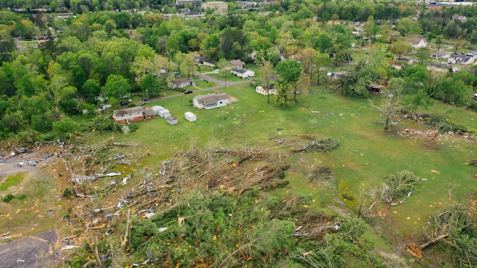
Tornadoes, Baseball-Sized Hail Strike Central Missouri Counties
Multiple tornadoes and baseball-sized hail battered central Missouri Saturday evening as severe storms prompted widespread warnings across the region.
SPRINGFIELD, MISSOURI — Severe thunderstorms spawned multiple tornadoes and produced baseball-sized hail across central and southwestern Missouri Saturday evening, prompting warnings from the National Weather Service Springfield office.
The most dangerous tornado warning was issued at 7:54 PM CDT for western Hickory County, northeastern Cedar County, northwestern Polk County, and southeastern St. Clair County. Weather spotters confirmed a tornado capable of producing baseball-sized hail moving east at 25 mph. The warning remained in effect until 8:45 PM CDT.
“Flying debris will be dangerous to those caught without shelter. Mobile homes will be damaged or destroyed,” according to the National Weather Service warning for the tornado located 10 miles east of El Dorado Springs.
Multiple Tornado Warnings Issued
Weather officials issued at least six separate tornado warnings between 7:09 PM and 8:19 PM CDT across the region. A tornado warning for southern Polk County and north central Greene County remained active until 9:00 PM CDT, with weather spotters reporting a funnel cloud near Walnut Grove.
The storms produced varying sizes of hail throughout the evening, with reports of two-inch hail in Greenfield and tennis ball-sized hail near Weaubleau. The largest hail, described as baseball-sized, was radar-indicated in storms moving through Hickory County.
Wind gusts reached up to 70 mph in some areas, with the National Weather Service warning of considerable tree damage and damage to mobile homes, roofs, and outbuildings.
Lake of the Ozarks Region Hit Hard
The Lake of the Ozarks region faced multiple severe thunderstorm warnings, with storms producing 60 mph winds and quarter-sized hail. Areas impacted included Lake of The Ozarks, Lake of The Ozarks State Park, Eldon, Osage Beach, Lake Ozark, Iberia, Vienna, St. Elizabeth, Tuscumbia, Eugene, Olean, Bagnell, Lakeside, Brinktown, Ulman, Etterville, Lakeview, Kaiser, Marys Home, and Aurora Springs.
Camden County experienced severe thunderstorms with half dollar-sized hail and 60 mph winds, affecting Camdenton, Village of Four Seasons, Sunrise Beach, Macks Creek, Linn Creek, and Climax Springs, among other communities.
Destructive Storms Target Multiple Communities
Weather officials designated certain storms as “destructive” for specific communities, including Urbana, Pittsburg, and Leadmine. These storms carried baseball-sized hail and posed severe injury risks to people and animals outdoors.
Communities in the path of various warnings included Bolivar, Stockton Lake, Stockton State Park, Humansville, Osceola, Hermitage, Weaubleau, Wheatland, Preston, Cross Timbers, Collins, Flemington, Roscoe, Vista, Gerster, Quincy, Fristoe, El Dorado Springs, Appleton City, Lowry City, Walker, Schell City, Harwood, Harper, Iconium, Tiffin, Johnson City, Taberville, Cedar Springs, and Monegaw Springs.
The storms moved generally eastward at speeds ranging from 20 to 50 mph, with most warnings expiring between 8:30 PM and 9:45 PM CDT Saturday evening.
Flooding Concerns Continue
In addition to the severe thunderstorm and tornado activity, the National Weather Service issued a flood watch for the Little Osage River near Horton and the Osage River at Taberville, effective from Tuesday afternoon through late Wednesday evening.
At 7:45 PM CDT Sunday, the Little Osage River stage measured 33.5 feet, with forecasters predicting flood stage of 41.0 feet could be reached by early Tuesday afternoon. Minor flooding at that level affects low-lying areas near the gauge site and farmland along the river.