Michigan Rivers Hit Major Flood Levels as Snowmelt, Rain Overwhelm State
Multiple Michigan rivers surge past flood records as dam releases and rapid snowmelt create dangerous conditions across the state’s northern regions.
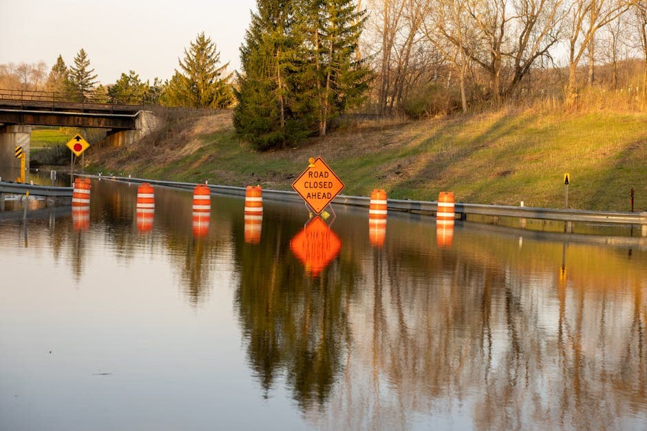
DETROIT, MICHIGAN — Multiple Michigan rivers reached major flood levels Monday as dam releases, rapid snowmelt, and heavy rainfall combined to create dangerous conditions across northern and central regions of the state.
The Au Sable River near Red Oak exceeded its flood record Monday, reaching 8.5 feet and continuing to rise toward a predicted crest of 10.0 feet early Wednesday morning, according to the National Weather Service. The river’s flood stage stands at 7.0 feet.
Dam operators reported releasing high flows through both the Mio Dam and Tippy Dam Monday afternoon, triggering flash flood warnings for areas downstream. The Mio Dam releases affected western Alcona County and east central Oscoda County, with flooding occurring along the Au Sable River. Towns of Mio and McKinley, located approximately 9.5 miles downstream, face immediate flooding risks.
Flash Flood Warnings Issued for Dam Releases
At Tippy Dam, high flows released into the Manistee River prompted warnings for High Bridge Campground, situated about 3.5 miles downstream. The National Weather Service attributed the emergency releases to recent snowmelt and heavy rainfall affecting the Manistee River basin.
The flash flood warning for Mio Dam areas extends until 2:30 PM Tuesday, while the Tippy Dam warning remains in effect until 4:15 AM Tuesday.
Paint River Approaches Record Levels
The Paint River at Crystal Falls reached 6.7 feet Monday morning and forecasters upgraded the flood severity from minor to moderate, warning that levels could approach the flood of record. At 7.0 feet, waterfront park areas near the M-69 bridge and low-lying areas along the river in Crystal Falls become inundated.
The Robert Olson Walking Trail begins flooding at 5.0 feet, while the river exceeds bankfull stage at 5.5 feet. Parking areas upstream of M-69 face flooding when levels reach 8.0 feet.
Widespread Flooding Across Multiple Counties
The Pine River near Rudyard in Chippewa County is forecast to reach minor flooding Tuesday morning, with water expected to reach the deck of the Prairie Road bridge at 19.0 feet. Current levels stood at 12.3 feet Monday, with the river predicted to crest at 18.3 feet early Wednesday.
In Arenac County, the Rifle River near Sterling registered 9.5 feet Monday morning, well above its 6.0-foot flood stage. High water already impacts property south of Townline Road downstream of the Melita Road bridge.
The Middle Branch Escanaba River at Humboldt in Marquette County reached 4.3 feet Monday, approaching the 6.0-foot action stage. County Road FX begins flooding at 6.5 feet, with water reaching the bridge bottom at 7.0 feet.
Snowmelt Accelerates Flooding Risk
Warming temperatures are accelerating snowmelt throughout the week, according to weather service forecasts. The Black River near Bessemer reached 9.9 feet Monday morning, just below the 10.0-foot flood stage, with a predicted crest of 10.2 feet Monday evening.
A flood watch remains in effect through Wednesday morning for portions of central and western Upper Michigan, including Alger, Baraga, Delta, Dickinson, Iron, Luce, Marquette, Menominee, Northern Schoolcraft, Southern Schoolcraft, Gogebic, Keweenaw, Northern Houghton, Ontonagon, and Southern Houghton counties.
The Chocolay River near Harvey faces minor flooding from late Monday night through Thursday evening, with water beginning to inundate the M-28 parking lot and low-lying areas along Timber Lane at 9.0 feet.
Weather service officials warn that additional rainfall throughout the week could push rivers above current forecasts, creating potentially dangerous conditions for residents in flood-prone areas across Michigan’s northern regions.


